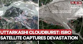
The flash floods in Dharali in Uttarakhand last week have significantly altered the course of the Bhagirathi river, according to new satellite images from the Indian Space Research Organisation (ISRO). The images show that the powerful floods have widened the river channels and changed its course, reports the Times of India.
The disaster began when the flash floods eroded a large section of debris on the Khirgad, a tributary of the Bhagirathi, located just above Dharali village. This erosion forced the Khirgad to return to its old course, diverting the flow of the Bhagirathi to its right bank.
Comparison of satellite images taken by ISRO’s Cartosat-2S on August 7 with previous images from June 2024 reveals the full extent of this change. A huge fan-shaped deposit, measuring about 20 hectares (about 750 metres by 450 metres), now exists at the confluence of the Khirgad and Bhagirathi. Satellite images have revealed that these new deposits have buried or submerged buildings, reshaped river courses and caused major changes to the local terrain.
Piyush Rautela, senior geologist and former executive director of the Uttarakhand State Disaster Management Authority, said old photographs showed a triangular fan of debris on the left bank of the Khirgad, just before it meets the Bhagirathi.
“This deposit was formed during a pre-catastrophic slope-lowering that diverted the course of the Khirgad at that time. Traditionally, such deposits were used only for agriculture, and houses were built on high, stable ground to avoid the risk of landslides and floods,” he was quoted as saying by the Times of India.
However, in recent years, increasing numbers of tourism and pilgrims, as well as commercial activities near the main road, have led to settlements springing up on these unstable reserves. “The flash flood removed the entire pile of debris, causing the Khirgad to return to its old course. The debris has temporarily pushed the Bhagirathi towards the right bank, but over time, the river will erode this material,” Rautela added.
Hydrologists warn that such sudden geomorphological changes can have far-reaching effects. A shift in the channel can increase water speed, change the way sediment flows and undermine riverbanks several kilometres away. These changes can threaten bridges, alter floodplains and create new erosion-prone areas, forcing riverside communities to adapt.
Dr Jagdish Krishnaswamy, dean of the School of Environment and Sustainability at the Indian Institute of Human Settlements, said the Himalayan region is particularly vulnerable. “These are the youngest mountains in the world – tectonically active, geomorphologically dynamic, and among the highest sediment loads generated globally. Retreat of glaciers, whether natural or accelerated by warming, releases huge amounts of debris, which can trigger avalanches and landslides when heavy rainfall occurs. This sediment can drastically alter river courses, especially where loose deposits are present on lower slopes or in narrow valleys,” he was quoted as saying by the Times of India.
He also warned that embankments and retaining walls can provide only an illusion of safety. “Due to the unstable terrain of the Himalayas and the ever-increasing rainfall, building on fragile ground is extremely risky. We must be very careful while planning infrastructure in these areas, otherwise we may expose people and property to disasters.