In a remarkable joint effort, an international and Indian group of scientists who understand the dangers associated with glaciers and parafrost on the mountains have assessed the cause of the disaster on February 7 in Uttarakhand. His assessment reveals many important things that increase our understanding of mountain catastrophes.
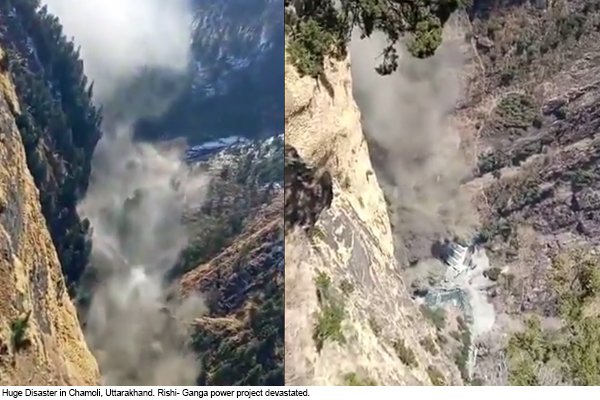
From 7 February 2021 onwards, national news was flooded with images and videos of massive flash floods in Chamoli district in Uttarakhand. The incident was caused by the breakdown of a portion of the Nanda Devi glacier and avalanche in the Alaknanda river system (Dhauli Ganga, Rishi Ganga and Alaknanda rivers). The flood swept hydropower stations and trapped several hundred laborers, many of whom may have died. Rescue operations are still ongoing and the amount of damage to human life, property and economy remains to be assessed. Two power projects – NTPC’s Tapovan-Vishnugad hydropower project and Rishi Ganga Hydel (hydropower) project, with homes in the low-lying areas of the villages, were extensively damaged.
Now it is important to understand some important things.
I. What were the causes of floods in Chamoli?
Scientists and environmental organizations are still researching the causes of floods in Chamoli district.
● Initial findings suggest that a major rock / ice avalanche separates itself from the north-facing slope north-east of Trishul Peak in the Nandadevi Mountains, at an altitude of about 5,600 meters above sea level. She went. This led to large scale flooding of the Rishiganga / Dhauliganga River. Analysis of satellite imagery from the area suggests that the event was caused by a failure deep within the base of the mountain, and glacier ice possibly associated with 2 bedrock’s collapsing blocks. The failed mass covered an area of about 0.2 km.
● The depth of the failure surface is more than 100 m below the surface, where no seasonal temperature variation is expected. The region is in permafrost conditions, which means that the ground temperature is always below zero. There are speculations that a change of heat from the warm southern face of the mountain to the cold north side, where the avalanche separated, may have warmed the frozen sheet, which could have led to the avalanche. In addition, melting of ice and ice may have infiltrated the base in the cleft systems and destabilize the rock through freeze-melting processes.
● Historical imagery indicates that a similar incident occurred in September 2016 in neighboring glaciers east of the present.
● Nevertheless, the onset of the failure as well as the final trigger of the avalanche remain unclear. It is also important to keep in mind that unstable geological configurations and steep (more sloping) topography can, on their own, be an adequate driver of large slope failures.
II. Where did such a large amount of water come from?
The origin of flood water is the biggest unanswered question. Initial conservative estimates give scientists strong confidence that the frictional melting of ice within the avalanche and the possible deposition of water stored in liquefaction (saturated) sediment generated enough water for flooding [1]. The very sloping avalanche trajectory falling at an altitude of about 3.3 km at an altitude of about 2000 m indicates the release of high impact energy. With the penetration, most of the glacier ice of the avalanche is melted. In addition, the area was under an ice cover of unknown depth, which is believed to have melted due to the frictional energy of the avalanche, as these many other cases suggest. Perhaps this melting of this snow and ice would have contributed a large amount of water to the runoff.
Several media stories speculated that the avalanche and subsequent floods created a temporary dam in one of the rivers Rishiganga and Dhauliganga that contributed to the floodwaters. While this dam was built, its direct involvement in flooding is unlikely. However, such damage arising from avalanche breakdowns creates a risk of future flooding if the dam breaks.
III. Is this another under-construction disaster?
● Recent high resolution satellite imagery indicates that mass movements are still occurring in the area where the initial rock and ice had failed. Another downhill failure and avalanche can be hazardous to people and downstream, near-riverbank infrastructure. It may also be a normal follow-up activity of the main event, but it cannot be overlooked that significant secondary events may occur.
● Large amounts of material have eroded and deposited along the river channel. Debris flows from these deposits can be triggered by a combination of water from rivers, ice melt, heavy (monsoon) rains or temporary overflow of lakes.
● Flood erosion may have weakened some sloping topographies, and this instability may affect roads, villages, and other infrastructure located far above, at the bottom of the river.
IV. Why is the frequency of natural disasters in the Himalayas increasing?
The Himalayas are a unique mountain system from the point of view of climate change and natural disasters. They are the youngest, tectonically active and geographically unstable mountains anywhere on Earth. Despite permanent ice cover, they have the highest rates of warming. This natural susceptibility to disasters is accelerated due to the effects of large-scale development such as climate change and urbanization, infrastructure development and hydropower projects. As towns and cities in the Himalayan region expanded, the number of people living in these areas increased rapidly, resulting in very high human costs at the time of disasters.
Impact of climate change in Himalayas
● According to a paper published in the journal Science in 2019, snow loss has doubled in the period 2000–2016 compared to 1975–2000.
● According to TERI’s 2018 discussion paper, the warming rate in the Himalayan region between 1986 and 2006 was 1.5 ° C and is projected to increase to 3 ° by mid-century.
● According to a study by ICIMOD, the glaciers of the eastern Himalayas tend to shrink faster than the central and western Himalayas. Glacier lake with 3 times higher risk in the eastern Himalayas is a flood outbreak. This makes the states of Jammu and Kashmir, Himachal Pradesh and Uttarakhand susceptible to the effects of climate change. Glacier lake flooding in the eastern Himalayas is at 3 times higher risk of flooding. This makes the states of Jammu and Kashmir, Himachal Pradesh and Uttarakhand susceptible to the effects of climate change.
Hydropower projects in the Himalayas
● In the next several decades, the Government of India aims to build 292 dams across the Indian Himalayas, which will double the current hydropower capacity and contribute an estimated ∼6% to the national energy needs by 2030 [2]. If all dams are constructed as proposed in 28 of the 32 major river basins, the Indian Himalayas will have one of the highest average dam densities in the world, with one dam for every 32 km of the river. Each of India’s neighbors with undeveloped hydroelectric sites is constructing or planning to build a minimum of 129 dams in total.
● India, Nepal, Bhutan and Pakistan all intend to build dams in the Himalayas falling within their geography. Together it will create more than 400 hydro-dams, which are expected to be the highest in the world.
Chances of natural disasters in Uttarakhand
● A recent independent analysis by the Energy, Environment and Water Council (CCEW) has revealed that more than 85% of the districts in Uttarakhand, which are home to more than 9 crore people, have been exposed to extreme floods and its related incidents. There are hotspots. The frequency and intensity of extreme flood events in Uttarakhand has increased fourfold since 1970. Similarly, flood events related to landslides, cloudbursts, glacial lake outbreaks, etc. have also increased fourfold over this time, causing widespread damage and damage. Chamoli, Haridwar, Nainital, Pithoragarh and Uttarkashi districts are in the grip of extreme floods.
● With the increase in extreme flood events, CEEW analysis also reveals that drought in Uttarakhand has doubled since 1970 and more than 69 percent of the districts in the state are vulnerable to it. Also, in the last decade, floods and drought have come together in Almora, Nainital, and Pithoragarh districts.
● According to a report released by the Ministry of Earth Sciences last year, the Hindu Kush Himalayas experienced a temperature rise of around 1.3 ° C during 1951–2014. The rise in temperature has led to microclimate change and rapid glacial retreat in Uttarakhand, causing frequent and recurrent flash floods. In the coming years, it could also affect the 32 major infrastructure projects underway in the state, valued at over INR 150 crores.
Experts have their own opinion on this whole assessment. Let’s have a look at them.
Dr. Christian Hagel, Environment and Climate: Impact, Risk and Adaptation (EClim), Glaciology and Geomorphodynamics, Department of Geography, University of Zurich
“The national (Indian) and international science community’s response to this disaster was excellent, with the first analysis being provided to officials only within 24 hours. The revolutionary development of satellite remote sensing of previous years was an important factor, but also the organization and coordination of the science community in international commissions such as GAPHAZ. An open, transparent and fruitful exchange between scientists and government officials and local stakeholders is necessary to prevent such disasters in the future.
While the Himalayan region is particularly vulnerable to and affected by climate change, the turn-over of mass movements (such as sediment fluxes, or extreme events in Chamoli), the failure of large sloping topography such as the Chamoli / Ronti peak case ( Rock-ice avalanche) is difficult to hold responsible for climate change. Such efforts require in-depth understanding and field and remote sensing data, for example geologic structure, permafrost occurrence and thermal distribution and disturbances, history of glacier degradation and mechanical stress changes in affected sloping topography. A thorough investigation of the case will improve our understanding at all levels and provide the basis for targeted actions. “
Dr. Carolina Adler, Executive Director, Mountain Research Institute, University of Bern
“In the long term, it is inevitable that in such high, remotely located, sloping, sensitive, rapidly warming and deglacialating environments, projects with large infrastructure may be exposed to considerable natural risks (sensu hazard × Vulnerability × risk). Nevertheless, the lack of long-term, informative data, the possibility of climate change-induced non-sustainability, and the complex, cascading nature of such events make it challenging to reliably quantify these risks. Hence such infrastructure The viability of projects should be re-examined. At least to protect those and infrastructure that are inherently in harm’s way (eg hydro-electric power stations), ongoing multi-variable monitoring of upstream environments, Multidimensional monitoring of upstream environments, combined with early warning systems that exploit modern technology and related mandatory drills, would seem imperative. ”
“MRI and one of its flagship initiatives – GEO Mountains – is ready to contribute to such efforts in some way, and therefore reaffirm our commitment to respond to the ‘call to action’ that is the WMO of 2019 The High Mountain Summit took place, with MRI executive director Dr. Carolina Adler was the co-chair. In particular, we strive to enhance the observation of Earth system processes in mountainous areas and to increase the availability and usability of related data, providing networking opportunities and fora in which a diverse range of stakeholders collaborate to drive progress Can, and together provide data and information that supports effective disaster risk mitigation and sustainable development policies — all of which will be critical to reducing the consequences of events whose frequency and severity increase in mountainous regions around the world is likely to. “
Dr. Indra D. Bhatt, Scientist, G.B. Pant Institute of Himalayan Environment and Development
The disaster took place in a village where the Chipko movement (hugging trees) was started and the views of local people indicated that the number of hydroelectric projects in this fragile ecosystem is responsible for such disasters apart from climate change. This is reflected in the “What we know so far” story on the Chamoli disaster of the Times of India. However, in-depth investigation is necessary for a detailed understanding.