New Delhi: Extremely severe cyclonic storm ‘Tauktae’ over east central Arabian Sea has moved almost northwards during last 6 hours at a speed of about 11 kmph and today, May 16, 2021 Indian Standard Time 05.30 hrs 15.9 degrees North.
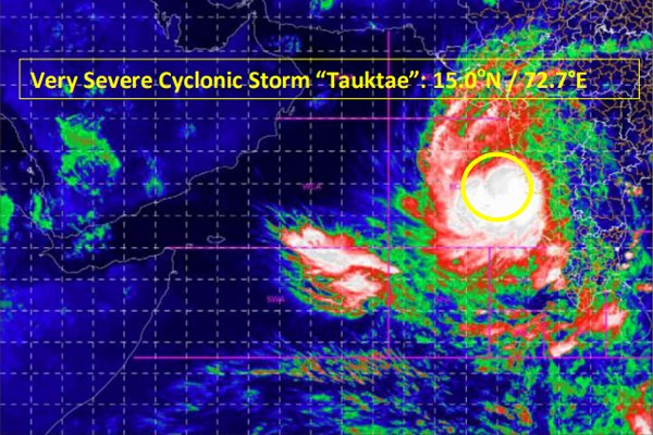
Near latitude and longitude of 72.7 degrees east, about 130 km west-southwest of Panaji-Goa, 450 km south of Mumbai, 700 km south-southeast of Viraval (Gujarat) and 840 km south of Karachi (Pakistan) Remained centered in the East.
It is expected to accelerate further during the next 24 hours. It is very likely to move towards north-northwest direction and reach Gujarat coast by evening of 17th and pass between Porbandar and Mahuva (Bhavnagar district) on the morning of 18 May.
Warning:
Rainfall:
Kerala: Light to moderate and heavy to very heavy rainfall is expected at many places on 16 and heavy rain at isolated places on 17 May.
Karnataka on 16 (coastal and adjoining ghat districts): Light to moderate rainfall is expected at most places and heavy to very heavy rainfall at different places.
Konkan and Goa: On May 16, light to moderate rainfall is expected in most places in Konkan and Goa and adjoining ghat areas and heavy to very heavy rainfall in some places and heavy rainfall is expected at different places on May 17.
Gujarat: Light to moderate rains start at several places over the coastal districts of Saurashtra from the afternoon of 16 May and heavy to very heavy rainfall at isolated places over Saurashtra and Kutch and Diu on 17 and extremely heavy rainfall at isolated places and On May 18, heavy to very heavy rainfall is expected at different places over Saurashtra and Kutch and Diu and very heavy rainfall (≥ 20 cm) at different places.
Rajasthan: On May 19, above South Rajasthan and on May 19 above Rajasthan, light to moderate and heavy to very heavy rainfall is expected at many places.
Wind warning
East of the central Arabian Sea, there is a strong wind reaching 130-140 kmph and reaching 155 kmph. It is expected to rise further to 145–155 kmph and 170 kmph above the Central Arabian Sea before the morning of 16 May.
Thunderstorms at 80-90 kmph along South Maharashtra-Goa and adjoining Karnataka coasts on May 16 and increasing to 100 kmph, with strong wind gusts reaching 50-60 kmph near the coastal region of Northern Maharashtra on 16 May. It is estimated to be flowing at a speed of 70 km per hour. From May 17 to the morning of May 18, it is expected to further accelerate along the coastal region of northern Maharashtra at 65-75 km per hour and speed up to 85 km per hour.
From the morning of 16 May, strong winds are expected to flow at a speed of 40-50 km per hour and above the coastal areas of North East Arabian Sea and South Gujarat and Daman and Diu and gradually increase to a faster speed of 60 km per hour. It is expected to reach 150-160 kmph and rise to 175 kmph in the northeast Arabian Sea and coastal areas of Gujarat (Porbandar, Junagadh, Gir, Somnath, Amreli) and again in the morning of 18 May. The time is estimated to flow at a speed of 120-150 km per hour over the Devbhumi Dwarka, Jamnagar, Bhavnagar districts of Gujarat and increase to 165 km per hour. From midnight of 17 May till the morning of 18 May, in the southern parts of Dadar, Nagar Haveli, Daman, Valsad, Navsari, Surat Bharuch, Ahmedabad, Anand districts, 70-80 kmph of thunderstorm and further increased to 90 kmph. It is estimated to flow at the speed of hours.
Sea conditions
On 16 May in the East Central Arabian Sea and on 17 and 18 May, the condition of the sea will remain very extreme to extremely extreme.
On May 16, the sea conditions will remain very extreme to very extreme in the coastal areas of Maharashtra-Goa and northern Maharashtra on the morning of 17 May. From the morning of 17 May it is expected to be very extreme to extremely extreme in the coastal areas of its passes and from midnight of 17 May.
Storm surge warning
About 1-2.5 meters above the astronomical tides in Junagadh, the coastal areas of Diu, Gir, Somnath, Amreli, Bharuch, Bhavnagar, Ahmedabad, Anand, Surat are expected to be submerged and the Devbhoomi during the rains hit the ground A wave of 0.5–1 m is expected in Dwarka, Jamnagar, Porbandar, Kutch and the remaining coastal districts of Gujarat.
Fishermen warning
All fish-related operations in the coastal areas of East Central Arabian Sea and Karnataka-Goa-Maharashtra have been completely suspended.
All operations related to fish have been completely suspended in the northeast Arabian Sea and coastal areas of Gujarat from May 17.
Fishermen have been suggested not to venture into the coasts of the northeast Arabian Sea and Karnataka until the morning of May 17 and the east central Arabian Sea and coastal areas of Karnataka-Goa by May 18 and the coastal areas of the northeast Arabian Sea and Gujarat.
Those who have gone to sea in the northern Arabian Sea have been suggested to return to the coast.
(A) Fear of loss in Kutch, Porbandar, Junagadh, Gir Somnath, Amreli, Jamnagar and Bhavnagar districts of Gujarat:
- Extensive damage to thatched houses completely demolished / kutcha houses. Some damage to pucca houses. Potential danger from flying objects.
- Power and communication poles can bend / dislodge.
- Major damage to raw and paved roads, flooding on exit routes, light damage to railways, overhead power lines and signaling systems.
- Extensive damage to salt pans and standing crops, fear of uprooting of bushy trees
- Smaller boats may differ from country craft moorings.
- Visibility severely affected
(B) Estimated loss of Devbhoomi Dwarka, Rajkot, Botad and Morbi districts:
- Heavy damage to thatched houses / huts. The roofs of the house can fly. Unattached metal sheets can fly.
- Slight damage to the poles of electricity and communication
- Major damage to kutcha roads and some damage to paved roads. Flooding on exit routes.
- Breaking of tree branches, uprooting of large avenue trees, slight damage to banana and papaya trees, large dry twigs can uproot trees.
- Damage to coastal crops
- Damage to dams / salt pans
Recommended Steps
- Emphasis on evacuation from sensitive areas
- Completely suspend fish operations
- Judicious exchange of rail and road traffic
- People stay in their homes in the affected areas
- Traffic in motor boats and small boats unsafe