New Delhi’s letter to Islamabad to amend the 1960 Indus Waters Treaty could not have come at a worse time for Pakistan, which is grappling with economic crisis and communal killings. This treaty was always a bone of contention between the two countries, with Pakistan seeing more violations of it.
According to the provisions of the Indus Waters Treaty (IWT), India controls the waters of the eastern rivers Beas, Ravi and Sutlej while Pakistan controls the waters of the western rivers Indus, Chenab and Jhelum, which are 20 and 80 percent of the total water . respectively by the Indus system.
Considering the geographical area and population disparity between the two countries, India should have been able to use maximum water from the Indus river and basin system. India followed the provisions of the IWT and refrained from doing anything that would amount to a violation.
Nevertheless, Pakistan twice approached the World Bank, the official mediator as per the treaty, which can be considered as baseless allegations. Pakistan was probably apprehensive for two reasons. One was that in the event of hostilities, India could use the Indus river system as a tool against Pakistan. Another issue that bothers Pakistan is India’s influence and credibility vis-a-vis Pakistan, which is negative to say the least.
India has never sought to use water as a tool in any war imposed on it by Islamabad. With regard to India’s credibility and capabilities to handle issues at the international level, Islamabad has a point. Rather than emerging as a failed state full of mercenary terrorist groups and a haven for non-state actors, nothing has stopped Pakistan from behaving and gaining the trust of the global community.
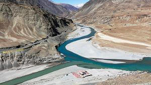
Nine tributaries of the Indus River, which form the Indus Basin, flow through Afghanistan, India, Pakistan, and Tibet (now under Chinese occupation). While the 1960 treaty only contemplates India and Pakistan, China’s acts of commission and omission with respect to the Indus Basin cannot be ignored.
Time to revisit the 1960 treaty
After several treaties and agreements and boundary negotiations with China, Tibet and Russia, in 1892 the British settled on a policy that their preferred boundary for Kashmir was the “Indus watershed”. In the Indus river system and on the other side in the Tarim basin. In the north this water-divide was along the Karakoram range. In the past, it was more complicated because the Chip Chap River, the Galwan River and the Chang Chenmo River flow into the Indus while the Karakash River flows into the Tarim Basin. A boundary alignment along this watershed was defined by Victor Bruce (Viceroy of India from 1894 to 1899) and communicated to London.
After the tragic partition, India became embroiled in land and water disputes with Pakistan over Kashmir, and with China over Aksai Chin and the Karakoram Range, as well as over Galwan and other river-flowing areas in the Ladakh valley. Thus, both Ladakh and PoK become important geographies in determining the resolution of the water-sharing settlement not only between India and Pakistan but also with China.
While India has never used its control over the origins of the Indus as a weapon in conflicts, the same cannot be said of China and Pakistan. As the upper riparian state of many transboundary riverine systems, China has the ability to manipulate water flows in the lower riparian states. China has avoided sharing drainage data with India and other low-lying riparian countries.
As the upper reaches of the Indus system of six rivers, India signed a treaty with Pakistan in 1960, which made no mention of Chinese-occupied territories or ceded by Pakistan to China. China not only denies equal distribution but has also started major dam construction projects in its occupied territory affecting the flow of Brahmaputra. A study developed through a reliable method based on satellite data from 1992 to 2019 to predict the natural flow of the Upper Mekong reveals how China’s cascade of dams on the Upper Mekong is changing the river’s natural flow.
With its complete control over Tibet, the “Water Tower of Asia”, China has complete and unimpeded access to major river basins such as the Indus, Brahmaputra (Yarlung Tsangpo in Tibet), Salween, Mekong, and Sutlej, which share the borders with India, Pakistan, Bhutan influences Myanmar, Thailand, Laos, Vietnam and Cambodia.
China’s dam-building activities severely affect water flow in the Indus and Sutlej, apart from the Brahmaputra. China has built dams/barrages on both the Indus and Sutlej rivers. These include the Senge Tsangpo and Nagari Shikwanhe hydroelectric stations on the Indus River and a barrage at Zada Gorge on the Sutlej River. It is also building the Basha and Bunji dams on the Indus River in the Gilgit-Baltistan region.