New Delhi: The Indian Meteorological Department (IMD) has predicted heavy rains in 5 states of the country during the next 24 hours, IMD said that at present there is a low pressure area over the Bay of Bengal, which is next There may be a deep pressure in 24 hours, due to which there is a possibility of storm in many states of the country, the department has issued an alert of heavy rain in Andhra Pradesh, Telangana, Karnataka, Madhya Maharashtra, Vidarbha and Odisha. Coastal areas may receive up to 20 cm of rain.
According to the Meteorological Department, due to the creation of this low pressure area, heavy rain is possible in Andhra Pradesh, Karnataka, Telangana, Madhya Maharashtra, Vidarbha and Odisha. There may be up to 20 cm of rain in the sea areas of these five states. In view of this possibility of heavy rain, a warning has been issued.
On Sunday, the India Meteorological Department has informed that the southwest monsoon is unlikely to return from the rest of the country by next week, which will further increase the rainy season. The low-pressure area over the Bay of Bengal could turn into deep pressure in the next 24 hours and cross the northern coast of Andhra Pradesh between Narasapur and Visakhapatnam on the night of 12 October. Apart from Andhra Pradesh and Telangana, due to this, the interior parts of North Karnataka, Madhya Maharashtra, Vidarbha and Odisha may receive rain on October 13.
According to the Cyclone Warning Department of India Meteorological Department (IMD):
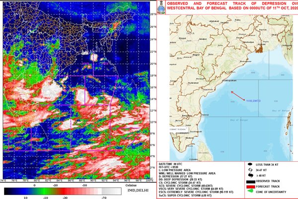
Recent satellite-based photographs and ships and marine signals available in the region revealed that a low pressure area was formed in the east-central region yesterday and a pressure zone is forming over the Bay of West Bengal adjacent to the southeastern Bay of Bengal. It is today i.e. 11 October 2020 at 0530 hours Indian time at 15.3 ° latitude and longitude 86.5 ° E, about 430 km southeast of Visakhapatnam (Andhra Pradesh), 490 km southeast of Kakinada (Andhra Pradesh) and 520 km south. -Focuses in the East.
It is very likely to move west-northwest during the night of 12 October 2020 and cross Narasapur and Visakhapatnam along the north Andhra Pradesh coast.
Light to very heavy rainfall at isolated places over coastal Andhra Pradesh, Telangana, Rayalaseema and interior Karnataka on 11 October 2020 with light to very heavy rainfall over most parts of coastal Andhra Pradesh, Telangana, Rayalaseema, Karnataka and Marathwada, South Odisha and South Chhattisgarh Moderate rain is expected.
With heavy to very heavy rainfall at isolated places over coastal Odisha, coastal Andhra Pradesh, Telangana, Karnataka, Marathwada and Vidarbha on 12 October 2020, most places in coastal Odisha, coastal Andhra Pradesh, Telangana, Karnataka, Marathwada and Vidarbha Light to moderate rain is expected.
Light to very heavy at isolated places over coastal Odisha, coastal Andhra Pradesh, Telangana, Karnataka, Marathwada and Vidarbha with heavy to very heavy rainfall at isolated places over coastal Odisha, coastal Andhra Pradesh, Telangana, Karnataka, Marathwada and Vidarbha on 13 October 2020. Is expected to receive moderate rain.
Extremely heavy rainfall (20 cm per day) is expected at isolated places in northern coastal Andhra Pradesh on 13 October.
Hurricane warning
On October 11, Andhra Pradesh-Tamil Nadu and Puducherry along with Odisha, West Central and North Bay of Bengal adjoining areas can gust at speeds ranging from 45-55 kmph to 65 kmph. There is a possibility of wind blowing along the coast of Andhra Pradesh-Tamil Nadu and Puducherry along with Odisha as well as Andhra Pradesh-Tamil Nadu and Puducherry at a speed of 60-50 kmph in the South West Bay of Bengal.
On 12 October, the northwest Bay of West Bengal and adjoining west, southwest Bay of Bengal can blow at a speed of 50-60 kmph. Apart from this, along with Andhra Pradesh coast, Odisha-Tamil Nadu and Puducherry coasts can also move from 55-65 kmph to 55-65 kmph.
On 11 and 12 October 2020, the adjoining areas of the northwestern and northwestern Bay of Bengal, the Gulf of Southwest Bengal and Odisha as well as the Andhra Pradesh-Tamil Nadu and Puducherry beaches and the Gulf of Mannar and on 13 October 2020 B. Strong waves can rise in the sea situated in the Gulf of Mannar.
Fishermen’s warning
Fishermen are advised to join the Bay of West Bengal and the Bay of North-West Bengal, Bay of South-West Bengal as well as Odisha-Andhra Pradesh-Tamil Nadu and Puducherry coasts and Gulf of Mannar on October 11 and 12, 2020. Do not go. Even on 13 October 2020, fishermen are advised not to venture into the Gulf of Mannar.
Also read in hindi: बंगाल की खाड़ी में तूफान की आशंका, 5 राज्यों में भारी बारिश का अलर्ट जारी