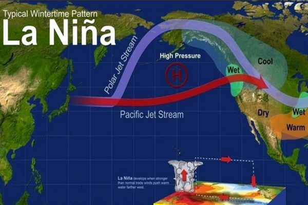
ENSO = El Niño/Southern Oscillation, the entire El Niño/La Niña system the condition of monsoon 2023, climate change will spoil the situation. The situation that arises when there is low air pressure on the surface of the equatorial Pacific Ocean region is called La Nina. Different reasons are considered for its origin, but the most popular reason is that it arises when the trade wind, the air flowing from the east, flows at a very high speed. This lowers the sea surface temperature significantly. It has a direct effect on the temperature around the world and the temperature becomes colder than average.
At present, the effect of La Nina is on its way out. With the irregularities in the cold temperatures of the oceans of the Pacific, their effect is now towards the end. According to the latest forecasts from the National Oceanic and Atmospheric Administration (NOAA), the first triple recurrence of La Niña in the 21st century will happen this year, and it is also the longest-lasting phase ever.
A third consecutive occurrence of La Nina in the Northern Hemisphere is a rare phenomenon and is known as a ‘triple dip’ La Nina. According to statistics, the effect of La Nina has been affected only twice since the year 1950 for three consecutive times. This happened between the years 1973-1976 and 1998-2001. According to NOAA, the longest duration of a La Nina effect was 37 months and was from the spring of 1973 to the spring of 1976. After that, between the years 1998-2001, its effect remained for more than 24 months.
But the most worrying thing is that dangerous effects like El Nino are making a comeback. According to the estimates of the models related to climate change, the effect of El Nino is likely to return during May-July. This period connects the summer and monsoon seasons. The monsoon period is considered to be from June to September.
Raghu Muratgudde, Emeritus Professor at the University of Maryland and Earth System Scientist at IITB, said, “During La Niña, the tropical Pacific absorbs heat like a soaker and the water temperature rises. This warm water flows from the western Pacific to the eastern Pacific during the El Niño effect. Three consecutive La Niña periods mean that the amount of warm water has peaked and there is a good chance that the system is ready to trigger an El Niño effect. Will it be as strong an El Nino effect as it was during 2015-16? We can feel some signs of this from the spring season itself.
By historical standards, to be classified as a full El Niño or La Niña episode, these limits must be exceeded for at least five consecutive overlapping three-month periods.
Relationship between El Nino and Southwest Monsoon
El Niño is invariably associated with poor monsoons and is seen as a threat. According to statistics, there is a 60 percent chance of drought in the country during an El Nino year. During this, there is a 30 percent chance of getting less than normal rainfall, while only 10 percent chances of normal rainfall remain.
Dr. Murtugudde said, “As far as the monsoon is concerned, if there is an El Nino effect in the summer season, then there is a high possibility of a reduction in rainfall. The transition from winter La Nina conditions (what we are experiencing now) to summer El Nino conditions poses the greatest risk of a deficit (15%) in the monsoon. This means that the pre-monsoon and monsoon circulation weakens.”
There is no fixed rule of law for the El Nino effect, so that it can be known how it will behave and how it will progress. For example, in 1997, despite the strongest El Nino effect, the monsoon received 102% of the rainfall. And in the year 2004, despite the weakening of the effect of El Nino, there was a severe drought and about 86% of the country was in its grip.
If we look at the data between 2009 and 2019, there are four such occasions when there was drought. There was a decline of 19% in the amount of rainfall in India in 2002 and 22% in 2009. Both these years are known as severe drought years. Similarly, in the years 2004 and 2015, there was a decline of 14-14 per cent in rainfall and both these years also witnessed drought. In the last 25 years, there has been only one such occasion (1997) when despite the effect of El Nino, the country received 2% extra rainfall ie 102% of the total.
G P Sharma, Head, Department of Meteorology and Climate Change, Skymetweather, said, “The El Nino effect forecast is available for the next nine months. Although model accuracy is generally low for timescales longer than four months at this time, the previous record El Nino signal around this time is evidence of a poor southwest monsoon. The ENSO forecasts for December 2013 and December 2017 were similar to those for December 2022.
Both these years saw the south-west monsoon rains causing moderate drought in 2014 and total drought in 2018. Earlier, in the years 2003 and 2008, the pattern of El Nino effect proved to be very bad, due to which the monsoon in India was very badly affected in 2004 and 2009 and both these years became witnesses of drought. Initial projections indicate that ENSO is intensifying and the El Nino effect also intensifies during the monsoon season. So far, the leading indicator of Nino 3.4 has remained in place and negative divergences still exist.
MJO and IOD may prove to be saviors of monsoon in El Nino year
The oceanic scale MJO (Madden-Julian-Oscillation) and IOD (Indian Ocean Dipole) are the two keepers of the Southwest Monsoon’s shield amidst the gloomy scenario of El Nino. Both these weather phenomena, if positive, indicate a good monsoon over the entire country and reduce the El Nino effect to a great extent. Although it is not yet clear whether this is a strong correlation. It is also not clear whether IOD will develop this year or not.
The MGO is a transient that patrols the Indian Ocean at least once and at most 4 times during the four-month monsoon season. Meanwhile, the IOB, also known as the Indian Nino, is an irregular oscillation of the SST sea surface temperature. In this, the western Indian Ocean becomes relatively warm and makes the eastern part cooler. It also affects the strength of the monsoon over the Indian subcontinent. A positive phase causes higher than average SST over the western Indian Ocean region and more precipitation with a corresponding cooling of the waters over the eastern Indian Ocean. On the other hand, negative IODs create opposite conditions.
Bi-way relationship between global warming and El Nino
Recent research suggests that the frequency of extreme El Niño events increases linearly with global mean temperature. In such a situation, the number of such events could double (one such event every 10 years) in the scenario of an increase of 10 ° C in global temperature. This trend is likely to continue for a century after the increase in global temperature has been stabilized at 1.5°C. This challenges the extent of adaptation and thus signals a greater risk even at the limit of 1.5°C.
Global average surface temperatures increase during and after El Niño, as the oceans transfer heat to the atmosphere. During El Nino, the cloud cover is destroyed by the warming of the water and the ocean surface becomes warmer due to solar radiation.
Dr. Murtugudde said, “During El Nino, we get mini global warming conditions, because the warm water spread over the tropical Pacific region releases a huge amount of heat into the atmosphere. Newspaper headlines are already testifying that this year’s El Niño could increase global warming beyond the level of 1.5 degree Celsius. Unfortunately it’s not clear whether that temporary deviation will cause anything dramatically beyond the extremes we’re already feeling. El Nino will surely bring its usual global troubles for cyclones and monsoons, wildfires, dust storms and so on.
Many researchers have already issued warnings. They project the frequency of extreme El Niño and La Niña events to increase from once every 20 years to once every 10 years by the end of the 21st century under extreme greenhouse gas emissions.
In warm climates, rainfall extremes are projected eastward along the equator in the Pacific Ocean during El Niño events and westward during La Niña extreme events. The potential evolution of rainfall patterns in the mid-latitudes is less clear, but if the frequency and amplitude of El Niño and La Niña increase, the extremes may become more pronounced.